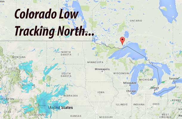
THUNDER BAY – WEATHER – Northwestern Ontario is headed into the snow zone. A low pressure system tracking into the region from Colorado is expected to impact the region starting on Wednesday. The system is likely to track west of the City of Thunder Bay. The forecast for the city as the weather system approaches the region on Wednesday is calling for snow becoming mixed with rain early in the afternoon. Snowfall amounts of 2 to 4 cm are forecast.
West of the city, Environment Canada has issued a Special Weather Statement for Northern Ontario as of 05:27AM EST on December 15th.
- Kenora – Nestor Falls
- Dryden – Ignace
- Fort Frances – Rainy Lake
- Atikokan – Upsala – Quetico
- Red Lake – Ear Falls
- Sioux Lookout – Savant Lake
The weather service states that, “Accumulating snowfall expected beginning Wednesday.. a Colorado low pressure system is forecast to track northeastwards towards the region, reaching northern Minnesota by Wednesday evening. This low pressure area is expected to spread a large area of snow into northwestern Ontario beginning overnight and continuing Wednesday.
Environment Canada is not stating that everyone should be battening down the hatches and that a major storm is coming. At this time of the year however with temperatures still not as cold as they usually are, travel conditions for both highways and air travel may be impacted.
The weather service says that there is uncertainty as far as total snowfall amounts are concerned. However, latest indications suggest most areas will receive 5 to 10 cm of snow by Wednesday evening. Periods of snow will likely continue Wednesday night into Thursday with further accumulation possible. Driving conditions are expected to deteriorate as the snow moves in. Motorists should be prepared for poor winter driving conditions on Wednesday and should consider allowing more time to reach their destination. Environment Canada is closely monitoring this situation.
Snowfall warnings may be required if the disturbance winds up being stronger than expected.


