
NASA’s TRMM Satellite Shows Tropical Cyclone Ita’s Australian soaking
After coming ashore on April 11, Tropical Cyclone Ita dropped heavy rainfall over the weekend that caused flooding in many areas of northeastern Australia’s state of Queensland. The Tropical Rainfall Measuring Mission satellite known as TRMM gathered data on rainfall that was used to create a rainfall map at NASA.
TRMM is a satellite managed by both NASA and JAXA, the Japan Aerospace Exploration Agency. At NASA’s Goddard Space Flight Center in Greenbelt, Md. Hal Pierce created a TRMM-based near-real time Multi-satellite Precipitation Analysis (TMPA). The TMPA precipitation data covered the period from April 1 to 14, 2014 which starts when Ita formed in the Coral Sea and moved along northeastern Australia’s coast. This TRMM satellite rainfall map estimated that some of the largest isolated rainfall totals were near 400 mm/15.7 inches west of both Ingham and Townsville, Queensland.
 |
||||
A 3-D image of Ita was made at NASA using data collected by the TRMM satellite on April 14, 2014 at 0416 UTC/12:16 a.m. EDT after the tropical storm moved back into the Coral Sea. TRMM’s Precipitation Radar (PR) instrument found that the weakening tropical cyclone was still dropping rainfall at a maximum rate of over 161 mm/6.3 inches per hour over the Coral Sea. The 3-D image, created using TRMM PR data, showed that some storms within Ita were still reaching heights of over 13 km/8 miles as it was becoming extra-tropical.
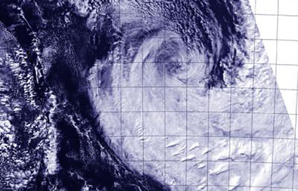
Another NASA-shared satellite captured a visible look at Ita’s remnants on April 15. The Visible Infrared Imaging Radiometer Suite (VIIRS) instrument aboard NASA-NOAA’s Suomi NPP satellite captured a look at the dying extra-tropical storm. VIIRS collects visible and infrared imagery and global observations of land, atmosphere, cryosphere and oceans.
When Suomi flew over Extra-Tropical Storm Ita on April 15 at 3:53 UTC/April 14 at 11:53 p.m. EDT, VIIRS visible data revealed that Ita’s structure had elongated more than the previous day. The VIIRS image showed that strong northwesterly wind shear continued to hammer the storm because the bulk of the storm’s clouds were pushed southeast of the center. Ita’s remnants have taken on more of a frontal appearance today as they continue to weaken at sea.
