Special Weather Advisory in effect!
Heavy Snowfall, Ice Pellets, and Freezing Rain Likely for Thunder Bay
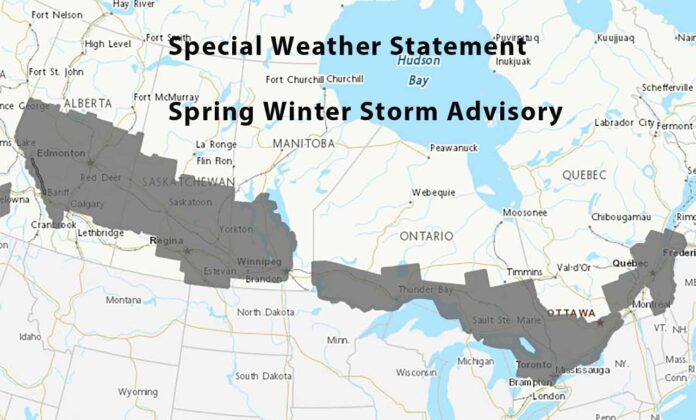
Special Weather Statement in Effect Through Saturday Morning
Thunder Bay, get ready to trade those early spring dreams for a snow shovel. Environment Canada has issued a Special Weather Statement for the City of Thunder Bay ahead of a messy spring storm that’s set to roll in from the west on Friday and stick around into early Saturday. It’s not quite time to pack away the winter boots just yet.
Snow Totals Could Reach 20+ cm – Or More
The low-pressure system fueling this system has all the hallmarks of classic March mayhem: heavy snowfall, a risk of freezing rain and ice pellets, and the potential for reduced visibility and difficult travel conditions. Current forecasts suggest 10 to 20 cm of snow is likely, but some areas could receive more than 20 cm depending on how much mixing occurs with ice pellets and freezing rain.
Communities near the U.S. border may see more icy precipitation, which could impact total snow amounts but increase the risk of slick and hazardous driving conditions. Snowfall amounts are still uncertain due to the shifting nature of the system, but confidence is growing that Thunder Bay will be hit with significant weather impacts starting Friday morning.
Current Conditions in Thunder Bay
As of this morning, Thunder Bay is sitting just around the freezing mark. Winds are coming in from the northeast at 18 km/h, and the humidity is at a damp 85%, adding to that heavy, moisture-laden feel in the air. The barometric pressure is 101.4 kPa and falling, a sure sign of the incoming storm.
Today’s historic high for March 26 is 17.6°C, a record set in 1946. The record low, on the other hand, is a biting -27.8°C, logged in 1974. While today’s weather isn’t breaking any records, it’s certainly more wintry than many were hoping for this far into March.
What to Wear: Winter Layers Are Still in Fashion
Don’t let the calendar fool you—this is a snowstorm worthy of full winter gear. Break out those warm, waterproof boots, insulated coats, gloves, and maybe even the snow pants if you’re headed out for a long walk. And if you’re hitting the roads, be sure your car emergency kit is stocked and ready.
Looking Ahead
The snow is expected to taper off by early Saturday, but not before making a mess of the region. With the potential for rapidly changing weather conditions, stay tuned to Environment Canada alerts and local road reports. Whether you’re staying put or planning to travel, Friday looks like a day to slow down, hunker down, and maybe catch up on some indoor spring cleaning instead.


