Thunder Bay – At the time of this update there were 79 active fires in the region. 30 fires are not under control, three fires are being held, 29 are being observed and 17 fires are under control.
There are evacuations for Deer Lake, Poplar Hill and Pikangikum.
Restricted Fire Zone in effect
Due to high to extreme forest fire hazard conditions, effective 12:01 a.m. Saturday July 10, the Ontario Ministry of Northern Development, Mines, Natural Resources and Forestry has issued updated boundaries for a Restricted Fire Zone in the Kenora, Fort Frances, Dryden and Thunder Bay Districts and portions of the Sioux Lookout, Red Lake, Nipigon and Wawa Districts. The Restricted Fire Zone will be in effect until further notice. Outdoor fires are banned. Portable gas stoves may still be used BUT must be handled with extreme care. You can learn more about Restricted Fire Zones here. For a more detailed boundary of the Restricted Fire Zone see the attached map, consult the interactive fire map at Ontario.ca/forestfire or find the map here.
Northwest Region
- There were 18 new fires confirmed in the northwest region by the late afternoon of July 13.
-
- Sioux Lookout 53 is located near Tamblyn Lake, approximately 58 kilometres northwest of Bearskin Lake in the far north. The 25 hectare fire is being observed.
- Kenora 76 was located near Roughrock Lake, approximately 13 kilometres north/northwest of Minaki. The 0.1 hectare fire is out.
- Nipigon 36 (3.6 hectares), Nipigon 37 (25 hectares) and Nipigon 39 (0.2) hectares are a cluster of fires ranging from 25 to 53 kilometres east of Nakina. Each of these fires is not under control.
- Dryden 57 is located near Canoe Island on Eagle Lake, approximately 10 kilometres south of Vermilion Bay. The 0.1 hectare fire is not under control.
- Red Lake 98 is located near the Bradburn River and the Manitoba provincial boundary, approximately 157 kilometres northwest of Red Lake. The 0.8 hectare fire is not under control.
- Nipigon 38 is located north of Toronto Lake, approximately 80 kilometres west/northwest of Nakina. The 1.0 hectare fire is not under control.
- Kenora 77 is located south of Umfreville Lake approximately 14 kilometres northwest of Wabaseemoong Independent Nation. The 0.1 hectare fire is not under control.
- Kenora 78 is located near Malachi Lake, approximately 8 kilometres northeast of Ingolf. The 0.8 hectare fire is not under control
- Dryden 58 is not under control at 2.5 hectares and is located near the Reba River, approximately 39 kilometres east of Ignace.
- Kenora 79 is not under control at 0.1 hectares and is located near Eaglenest Lake, approximately 67 kilometres northwest of Kenora.
- Kenora 80 is not under control at 0.1 hectares and is located near Skiff Lake, approximately 10 kilometres northwest of Kenora.
- Kenora 81 is not under control at 0.1 hectares and is located approximately 45 kilometres southeast of Kenora.
- Thunder Bay 67 is not under control at 0.1 hectares and is located near Goose Lake, approximately 76 kilometres northeast of Armstrong
- Thunder Bay 68 is not under control at 0.1 hectares and is located near Ratte Lake, approximately 36 kilometres northeast of Armstrong
- Red Lake 99 is not under control at 0.1 hectares and is located on an island on Lee Lake, approximately 29 kilometres southwest of Red Lake.
- Red Lake 100 is not under control at 1 hectare and is located 94 kilometres northwest of Red Lake.
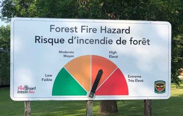
- The wildland fire hazard is high to extreme in the Fort Frances, Dryden, Thunder Bay and southern Nipigon districts. The Red Lake, Sioux Lookout, Kenora, and northern Nipigon districts have a mainly low to moderate hazard.
- Smoke drift in Red Lake, Kenora, Sioux Lookout, and Nipigon will continue to be experienced by communities in close proximity to wildland fires in those Districts and across the far north. Smoke drift from fires burning in the western provinces of Canada may also be detectable today across much of the province.
- AFFES is currently responding to many fires on the landscape. Stay informed of the location, size, status of all active wildland fires in the province on the interactive fire map atOntario.ca/forestfire
Fires of Note
Kenora 51
- Fire is not under control at 78,101 hectares.
- Crews are maintaining sprinklers on structures in the vicinity of the fire
- Fire has been active over the past several days producing smoke at the local level
- 21 crews and 13 helicopters are assigned to this fire.
- An Incident Management Team is established on the fire.
Red Lake 65
- Not under control at 7401 hectares
- Located approximately 13 kilometres southwest of Poplar Hill First Nation
- Crews are setting up sprinklers on structures in the vicinity of the fire.
- Aerial ignition is being used to bring the north-end of the fire to Stout Lake to limit the fire’s spread
- The fire received some rain.
- The Ministry of the Solicitor General is in the process of conducting an evacuation of Poplar Hill First Nation, as Aviation, Forest Fire and Emergency Services continues to respond to fire Red Lake 65 southwest of the community.
Red Lake 51
- Being observed and remapped to 35019 hectares
- Located 27 kilometres west of Deer Lake First Nation
- Crews are setting up sprinklers on structures in the vicinity of the fire.
- Air attack is focusing on the eastern side of the fire today.
- The Ministry of the Solicitor General is in the process of conducting an evacuation of the community.
Red Lake 68
- Not under control at 15000 hectares
- Located southeast of Pringle Lake, approximately 55 kilometres northeast of Red Lake.
- 6 Crews are setting up sprinklers on structures in the vicinity of the fire
Red Lake 77
- Not under control at 19251 hectares
- Approximately 36 kilometres west of Red Lake
- Crews are setting up sprinklers on structures in the vicinity of the fire.
Forest fire emergency restrictions to be lifted in the Fort Frances District
The Ministry of Northern Development, Mines, Natural Resources and Forestry is advising the public that the forest fire Implementation Order that was put in place due to extreme fire activity in the Fort Frances 47 area, will no longer be in effect as of July 13, 2021 at 10:00pm Central Standard Time. All restrictions related to the evacuation, travel, use and access of the previously identified areas will be lifted.
The public is reminded that Fort Frances 47 is an active fire with ongoing fire suppression. Please be mindful of crews working the fires and near roadways.
The interior of a forest fire is dangerous and the public should not enter this area. Trees with weakened root systems could fall over and cause injury. There will be visible smoke in the interior of this fire for some time. This is the normal process for extinguishing a forest fire.
The Ministry of Natural Resources and Forestry would like to thank the public for their cooperation during this time.

