Highlights:
- Acquired and staked ground consolidates the largest felsic volcanic rock package in the Flin Flon Greenstone Belt, the host rock for the majority of the historic copper/gold/zinc/silver VMS mines in the Flin Flon and Snow Lake regions;
- Newly acquired ground hosts one gold deposit and a relatively recently interpreted growth fault corridor known to control and host at least two historic near-surface copper-rich VMS deposits and numerous Cu-Zn VMS occurrences;
- Growth fault corridor that hosts those two historic resources is similar to a parallel growth fault corridor that hosts Rainbow, Pine Bay, Descendent and other deposits 3km to the south; and
- Ground has been subject to limited very shallow exploration drilling on limited portions of the large land package.
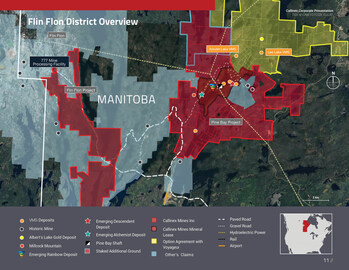
VANCOUVER, BC, May 20, 2024 – Mining Press Release – Callinex Mines Inc. (the “Company” or “Callinex”) (TSXV: CNX) (OTCQX: CLLXF) is pleased to announce it has signed an option agreement with Voyageur Mineral Explorers Corp. (“Voyageur”) to acquire a 100% interest in the Alberts Lake Project and staked additional claims to grow the Company’s flagship 100% owned Pine Bay Project (the “Project”) located in the Flin Flon Mining District of Manitoba (Flin Flon District Overview Map). Callinex’s Pine Bay Project now encompasses over 11,859 hectares (approximately 120 square kilometers) of highly prospective exploration ground and completely consolidates the Baker Patton Felsic Volcanic Complex (“Baker Patton”) and another large felsic package known as the Alberts Lake Felsic Volcanic Complex (Pine Bay Project Geology). Combined, the Baker Patton and Alberts Felsic Complex contains the largest and most highly altered accumulations of surface exposed felsic volcanic rocks in the Flin Flon region. Felsic volcanic rocks also host almost all of the main copper, gold, silver and zinc bearing Volcanogenic Massive Sulphide (“VMS”) deposits and mines discovered within the Flin Flon Greenstone Belt (Flin Flon Regional Geology).
Max Porterfield, President and CEO, stated, “Consolidating this highly prospective land package in the Flin Flon Greenstone belt is a significant achievement for Callinex. As we continue to advance our high-grade copper discoveries to the south, we are eager to apply our proven exploration model on key high-grade copper and gold targets within the newly acquired ground.”
Jim Pickell, a member of Callinex’s technical team, added, “I’m thrilled to have a fresh new opportunity to help unravel the mineral potential of the Baker Patton Felsic Volcanic Centre and to further unlock its exceptional VMS endowment known to be associated with intense geochemical alteration zones confined within major transverse growth fault corridors spaced at three-kilometre intervals along strike. This is particularly true of the prospective northernmost fault corridor, first identified by Callinex in 2015 and occurring in an area that the company couldn’t access at that time. This northernmost interpreted fault corridor has really only seen a rather limited number of mostly shallow drill holes focussed on the historic Amulet and Leo Lake VMS occurrences. Given Callinex’s freshly acquired Pine Bay geological, geochemical and geophysical perspectives that were used to discover the Rainbow, Alchemist and Descendent VMS deposits along the adjacent fault corridor to the south, it’s an entirely new exploration game for Callinex.”
The Alberts Lake Project encompasses 5,064 hectares of contiguous ground to the north of the existing Pine Bay Project boundary. The land package contains several prospects hosting both copper-zinc-gold-silver bearing VMS mineralization as well vein-hosted gold-silver. More recently, vein-hosted gold has been targeted for exploration near the Albert’s Lake Gold Prospect and along the strike extent of the structure, the Albert’s Lake Shear, hosting mineralization that has been traced at surface and by drilling for over 2km of strike extent.
VMS discoveries of note within the Flin Flon – Snow Lake Greenstone Belt have often been made by drilling considerably down-plunge from small, precious and base metal-rich VMS lenses directly associated with interpreted growth fault corridors that ultimately controlled the discharge of VMS systems at regular intervals (often two kilometres or less) down those plunge lines, ultimately leading to much larger and economically viable deposits. For example, two near-surface, rather small but high-grade VMS lenses, the “Dan” and “Owens” lenses, were the small precursors for the much larger 25+ million tonne 777 deposits discovered much deeper down-plunge. It’s also worth noting that the Company’s most recent discovery, the Descendent VMS, is similarly located significantly down-plunge from the near-surface high-grade Cabin VMS deposit. In any event, historic near-surface mineralization will be a main focus for initial target generation on the newly acquired land package.
While the Leo Lake area has been known for several decades for its anomalous levels of VMS mineralization, the presence of significant mineralization within the Leo Lake deposit was not identified until 1991. In March of that year, Granges drilled hole AL-113 which intersected 8.38% Cu and 0.96% Zn over 2.13m. In 1997, Aur Resources compiled all the previous drilling information, creating sections and level plans. The results indicated that the Leo Lake deposit was made of four lenses of VMS mineralization (known as the 21, 22, 23 and 24 lenses). Aur Resources generated a historical “geologically inferred mineral inventory” for the four lenses, based on a reinterpretation of the Granges drilling, of 192,292 t (short tons) grading 2.29% copper and 0.91% zinc (see “Historical Resource Estimate” disclosure below).
In 1998, Aur drilled (DDH 98-LW-18) into a new massive sulphide lens, below the 23 and 24 zones which they termed the 159 Corridor, intersecting the zone with four holes. Drilling intercepts into the 159 Corridor include 1.52m grading 3.13% Cu, 10.46% Zn, 10.4 g/t Ag and 1.28 g/t Au, 1.46m of 2.56% Cu, 0.78 g/t Au and 11.58m of 1.21% Cu. Subsequently, in 1999, three holes were drilled to target the 159 horizon and intersected narrow widths of modest grades.
The Albert’s Lake Gold deposit is located along the Alberts Lake shear zone northwest of Leo Lake. It is characterized by the presence of quartz veins in strongly altered, sheared and pyritic gabbro. The veins are composed predominantly of quartz with very minor iron-carbonate.
The largest of the gold prospects within the Alberts Lake Gold deposit has 500 meters of strike length and a vertical extent of 300 meters. In the late 1980s, drilling by the previous operators intersected significant gold grades, including high-grade intercepts, as follows:
- 276.20 g/t Au and 7.60 g/t Ag over 1.2m (including 659.9 g/t Au over 0.5m) (AL-16)
- 16.75 g/t Au and 29.48 g/t Ag over 5.5m (AL-40)
- 34.77 g/t Au and 11.73 g/t Ag over 1.8m (including 195.0 g/t Au over 0.3m) (AL-57)
- 39.95 g/t Au and 22.65 g/t Ag over 1.0m (AL-58)
- 32.81 g/t Au and 60.53 g/t Ag over 1.2m (AL-85)
- 3.46 g/t Au over 27.9 m (including 12.19 g/t Au and 33.5 g/t Ag over 4.5 m) (AL-11-57TW)
- 1.02 g/t Au over 51.5 m (including 6.82 g/t Au and 14.0 g/t Ag over 2.85 m) (AL-11-61BTW)
- 1.39 g/t Au over 30.9 m (including 5.83 g/t Au and 10.5 g/t Ag over 2.2 m) (AL-11-40TW)
- 1.14 g/t Au over 26.4 m (includes 4.55 g/t Au and 7.1 g/t Ag over 1.85 m) (AL-11-72TW)
Historical assay information obtained from Geological Reports prepared by Granges, Aur Resources Inc. and Copper Reef Mining Corporation.
The near surface Amulet VMS deposit has not been explored at depth and previous drilling results include:
- 5.06m at 1.43% Cu, 0.42 g/t Au and 3.84 g/t Ag (Amulet-2)
- 4.26m at 3.2% Zn, 0.42 g/t Au and 0.42 g/t Ag (Amulet-6)
- 5.33m at 1.43% Cu, 0.61 g/t Au and 1.97 g/t Ag (Amulet-11)
- 0.79m at 2.38% Cu, 4.5% Zn, 1.37 g/t Au and 24.59 g/t Ag (Amulet-15)
The largest proportion of work carried out in the Amulet Lake area was done by Hudbay between 1945-53 during which time 61 drill holes tested several targets. Subsequent exploration by Guggenheim Exp. (1969-72) and Granges Exploration (1980-84) tested specific targets (total 7 drill holes). The historic Amulet deposit hosts three small VMS lenses. The horizon that hosts Amulet has also been explored by trenching and an adit in addition to the above drilling. The Amulet Lake deposit is interpreted to occur three kilometres to the northeast along strike from the Company’s Rainbow Deposit and sitting within the exact same felsic volcanic stratigraphy.
Under the terms of the option agreement, Callinex will acquire a 100% interest in the Alberts Lake Project by making the following share issuances to Voyageur:
- $75,000 of common shares on the date of TSX Venture Exchange acceptance;
- $150,000 of common shares on the first anniversary;
- $150,000 of common shares on the second anniversary;
- $150,000 of common shares on the third anniversary;
- $150,000 of common shares on the fourth anniversary.
Upon Callinex acquiring a 100% interest in the Alberts Lake Project, Voyageur will be granted a 1.5% net smelter return royalty, of which 0.5% may be repurchased with a one time payment of $500,000. A portion of the claims are subject to a historical back-in right as well as an underlying net profit royalty.
This transaction is subject to the approval of the TSX Venture Exchange.
J.J. O’Donnell, P.Geo, a qualified person under National Instrument 43-101, has reviewed and approved the technical information in this news release. The historical assay information was reviewed from historical geological reports filed by the previous operators of the Alberts Lake Property.
Callinex Mines Inc. (TSXV: CNX) (OTCQX: CLLXF) is advancing its portfolio of base and precious metals rich deposits located in established Canadian mining jurisdictions. The focus of the portfolio is highlighted by the rapidly expanding Rainbow deposit at its rich VMS Pine Bay Project located near existing infrastructure in the Flin Flon Mining District. Callinex prepared an indicated mineral resource on the Rainbow deposit of 3.44 Mt grading 3.59% CuEq for 272.4 Mlb CuEq (238.3 Mlb Cu, 56.9 Mlb Zn, 37.6 koz Au, 692.8 koz Ag, 2.3 Mlb Pb), an inferred mineral resource on the Rainbow deposit of 1.28 Mt grading 2.95% CuEq containing 83.4 Mlb CuEq (72.1 Mlb Cu, 19.5 Mlb Zn, 11.1 koz Au, 222.2 Koz Ag, 0.8 Mlb Pb) and an inferred mineral resource at the Pine Bay deposit of 1.0 Mt grading 2.62% Cu containing 58.1 Mlb Cu (see news release dated July 10, 2023). The second asset in the portfolio is the Nash Creek Project located in the VMS rich Bathurst Mining District of New Brunswick. A 2018 PEA generates a strong economic return with a pre-tax IRR of 34.1% (25.2% post-tax) and NPV8% of $230 million ($128 million post-tax) at $1.25 Zinc (see news release dated May 14, 2018). The third asset, 100% owned Point Leamington Deposit in Newfoundland, is located in one of the richest VMS and Gold Districts in Canada. Callinex prepared a pit constrained Indicated Mineral Resource of 5.0 Mt grading 2.5 g/t AuEq for 402 koz AuEq (145.7 koz gold, 60.0 Mlb copper, 153.5 Mlb zinc, 2.0 Moz silver, 1.5 Mlb lead), a pit constrained Inferred Mineral Resource of 13.7 Mt grading 2.24 g/t AuEq for 986.5 koz AuEq (354.8 koz gold, 110.2 Mlb copper, 527.3 Mlb zinc, 6.2 Moz silver, 7.0 Mlb lead) and an out-of-pit Inferred Mineral Resource of 1.7 Mt grading 3.06 g/t AuEq for 168.5 koz AuEq (65.4 koz gold, 13.3 Mlb copper, 102.9 Mlb zinc, 1.4 Moz Ag, 2.6 Mlb lead) (see news release dated October 25, 2021).
Historical resource estimates include a geological report titled “The 1997 and 1997 diamond drilling programs on the Lew Property” dated June 1993, prepared by Aur Resources Inc., reported an “inferred mineral inventories” of 192,292 t (short tons) at 2.29% Cu and 0.91% Zn at the Leo Lake Copper deposit and the historical resource estimates cited above are mentioned for historical purposes only and use terminology not compliant with current reporting standards. The reliability of these historical estimates is unknown but considered relevant by the Company as they represent significant targets for future exploration work by the Company. The assumptions, parameters and methods used to calculate this historical resource estimate are not known to the Company. The qualified person has not made any attempt to re-classify the estimates according to current NI 43-101 standards of disclosure or the CIM definitions. In order for these resources to be current, the Company will be required to conduct additional drilling on the Alberts Lakes Property. The Company is not treating this estimate as current mineral resources or mineral reserves as defined in NI 43-101.
Some statements in this news release contain forward-looking information. These statements include, but are not limited to, statements with respect to future expenditures. These statements address future events and conditions and, as such, involve known and unknown risks, uncertainties and other factors which may cause the actual results, performance or achievements to be materially different from any future results, performance or achievements expressed or implied by the statements. Such factors include, among others, the ability to complete the proposed drill program, raise additional capital for exploration activities, obtaining satisfactory results from its drill program and the timing and amount of expenditures. Except as required under applicable securities laws, Callinex does not assume the obligation to update any forward-looking statement.
Neither the TSX Venture Exchange nor its Regulation Services Provider (as that term is defined in the policies of the TSX Venture Exchange) accepts responsibility for the adequacy or accuracy of this release.
SOURCE Callinex Mines Inc.

For further information: Callinex Mines Inc., Max Porterfield, President and Chief Executive Officer, Phone: (604) 605-0885, E-mail: info@callinex.ca


