Northeast Region: 19 Active Fires
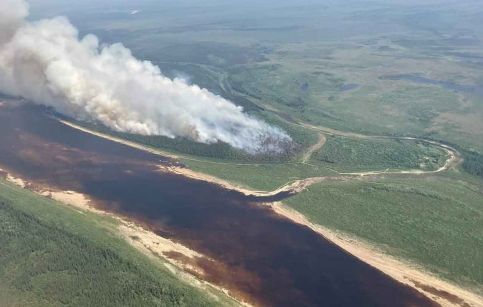
Sault Ste Marie – Wildfire Update – As of the latest update at 18:30, there are currently 19 active wildland fires in the Northeast Region. Among these, 4 fires remain uncontrolled, 4 are being held, 5 are under control, and 6 are under observation.
No New Fires Confirmed Today
Fortunately, no new fires have been confirmed in the region today. However, the existing fires continue to demand attention and resources from firefighting crews.
Fire Hazard Conditions
The fire hazard conditions vary across the region. Areas south of North Bay and Sudbury are currently experiencing a low fire hazard. Meanwhile, areas north of North Bay and Sudbury have a hazard level ranging from low to high, with the Cochrane district showing an extreme hazard. To get a detailed view of the fire hazard conditions in your area, refer to our interactive map.
Fires of Note
Several fires continue to garner attention due to their size and behavior:
- Cochrane 7: This fire, covering a massive 37,742 hectares, was confirmed on June 2. It is located northeast of Lake Abitibi and displays intense fire behavior. Despite ongoing efforts, it remains uncontrolled, with heavy equipment employed to suppress the fire perimeter.
- Cochrane 11: Confirmed on June 17, this fire is estimated to be 805 hectares in size. Situated approximately 5 km west of Fort Albany and south of Big Island, FireRanger crews are making good progress in suppressing it. The fire is currently being held.
- Chapleau 3: Identified on June 1, this wildland fire spans 3,916 hectares and is located 2 kilometers south of October Lake and 2.5 kilometers west of Vichaw Lake. It remains uncontrolled.
- Chapleau 6: Confirmed on June 4, this fire covers an area of 1,228 hectares. It is situated 2.5 kilometers west of Morin Lake and 1 kilometer east of Bolkow Lake. Firefighting efforts are underway, but the fire remains uncontrolled.
- Sudbury 10: Verified on June 2, this fire measures 1,370 hectares. It is located 3 kilometers west of Fox Lake and 5 kilometers east of Acheson Lake. The fire is currently being held.
- Sudbury 17: Confirmed on June 4, this wildland fire spans 5,857 hectares. It is situated 3 kilometers west of Madawanson Lake and 0.5 kilometers east of Pilot Lake. Multiple crews are dedicated to this fire, which is currently being held.
Restricted Fire Zone in Effect
A restricted fire zone continues to be in effect for the entire fire region of Ontario, rendering outdoor fires prohibited. It is crucial for residents to exercise extreme caution in all activities that could potentially spark a fire, including parking or driving vehicles on dry grass or other flammable forest floors.
Firework Safety
Considering the heightened fire activity, we strongly advise exercising extreme caution when using fireworks. Attending organized fireworks displays is encouraged instead of setting off your own. The Forest Fire Prevention Act strictly prohibits leaving any residue from fireworks unextinguished within 300 meters of a forested area. Offenders may be charged and held accountable for the cost of extinguishing any resulting fire. Local municipalities may also have their own burn bans or by-laws regarding fireworks.
Implementation Orders
Several implementation orders are currently in place, affecting travel, use, and access in specific areas. Please refer to the following details:
- MNRF Sudbury District – Travel, use, and access restrictions are implemented for Highway 810 (Massey Tote Road) between Ritchie Falls and Madawanson Lake Rd. Travel permits from the Sudbury District Ministry of Natural Resources and Forestry are required.
- MNRF Hearst-Cochrane-Kapuskasing District (COC006 and COC007 fires) – Restrictions are in place for the Translimit Road and Crossover Roads between Translimit-Bingle Road junction and the Ontario-Quebec border. Occupancy and use of Crown Land and roads in specified townships are also prohibited. Travel permits can be obtained from the Hearst-Cochrane-Kapuskasing District office.
- MNRF Chapleau-Wawa District (CHA003 fire) – The Wakami River Road and Benton Road are closed for travel and use. Travel permits issued by the Chapleau-Wawa District Ministry of Natural Resources and Forestry are required.
Help Fight Forest Fires: Stay Clear of Waterbombers and Drones
When waterbombers approach a body of water, ensure you move close to the shore, allowing them to safely scoop water. Waterbombers will not scoop from a lake or river if nearby watercraft pose a safety risk. Additionally, flying drones near forest fires is both dangerous and illegal. Drones can jeopardize the lives of pilots, firefighters, and emergency personnel. Please prioritize safety and avoid flying drones near forest fires.
Report a Wildland Fire
To report a wildland fire north of the French and Mattawa rivers, dial 310-FIRE. For fires south of these rivers, please dial 911. Prompt reporting is crucial in effective fire response and containment efforts.
This is the NetNewsLedger wildfire report, providing you with the latest updates on the Northeast wildfires.


