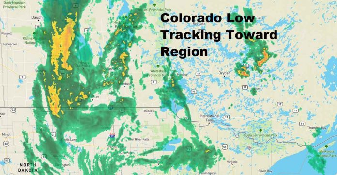
Falcon Lake – Weather – As the area of low pressure moves through the Midwestern states towards the Great Lakes on Wednesday night and into Thursday, a hang back area of snowfall is expected to linger over southeastern Saskatchewan and southern Manitoba through the week. At this time, it appears that for each forecast period, snowfall amounts are expected to stay sub-warning. However, with the snow beginning overnight on Tuesday and continuing through the week, the accumulation of snow over such a prolonged time will have continuous impact over the region. The accumulations will range from 10-20 cm, with some local amounts reaching as high as 30 cm by the weekend.
4:01 AM CST Tuesday 13 December 2022
Special weather statement in effect for:
- Falcon Lake and West Hawk Lake
- L.G. of Pinawa incl. Seven Sisters Falls
- Pointe du Bois
- R.M. of Lac Du Bonnet
- R.M. of Reynolds incl. Ste. Rita Hadashville and Rennie
- R.M. of Whitemouth incl. Elma
- Shoal Lake Reserves
A prolonged snow event over southeastern Saskatchewan and southern Manitoba beginning late Tuesday evening with some local areas receiving upwards of 20-30 cm by the weekend.
Ahead of a Colorado low, some light snow and freezing drizzle will continue over southern Manitoba on Tuesday morning. The Colorado low will move through the upper Midwest of the United States bringing snow into the region starting Tuesday night and into Wednesday. With the above seasonable temperatures in place as the low pressure system approaches, the snow is expected to be a heavier wet snow. The worst conditions are expected to be in the communities along the international border.
As this area of precipitation lingers, some regions in eastern Saskatchewan and western Manitoba may see higher snowfall amounts as the system interacts with the higher terrain in the region.
Conditions will improve Friday into Saturday as the Colorado low continues to track eastward, ushering in another surge of Arctic air, bringing back more normal temperatures.


