Extreme fire hazard in northwest region
Thunder Bay – At the time of this update there are 49 active fires in the northwest region. Nine fires are not under control, 10 fires are being held, 12 fires are under control, and 18 fires are being observed. Four fires were called out today.
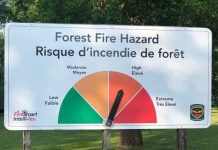
The hazard ranges from Extreme to High across the district.
There is also smoke from fires showing up is hazy conditions as well.
- Extreme forest fire hazard conditions continue to grip the western half of the northwest region including Kenora, Red Lake, Dryden, Fort Frances and Sioux Lookout districts. Thunder Bay and Nipigon Districts feature a high to extreme hazard. Residents beyond the boundaries of the Restricted Fire Zone are asked to consider avoiding outdoor burning while such hazardous conditions persist.
- To see the fire hazard near you, consult the interactive fire map at Ontario.ca/forestfire
- Five new fires were discovered in the northwest region by the late afternoon of July 3.
- Nipigon 15 is located near Shacabac Lake, approximately 55 kilometres east/southeast of Nakina. The 0.2 hectare fire is not under control.
- Sioux Lookout 43 is located near Williams Lake, approximately 49 kilometres northwest of Pickle Lake. The 10 hectare fire is being observed.
- Fort Frances 54 is located south of Britton Lake, approximately 57 kilometres south of Fort Frances. The 0.5 hectare fire is not under control
- Red Lake 56 is located on the southern shore of Sandy Lake, approximately five kilometres southeast and across the lake from Sandy Lake First Nation. The 0.3 hectare fire is not under control.
- Nipigon 14 is located west on Onaman Lake, approximately 62 kilometres northwest of Geraldton. The fire, which received air attack today, is not under control at 4.0 hectares.
- Several additional fires were located in the evening hours of July 2 following the previous update.
- Sioux Lookout 39 is located near Upturned Root Lake, approximately 74 kilometres northwest of Pickle Lake. The 469 hectare fire is being observed.
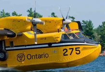
- Red Lake 55 is located near Wagner Bay on Birch Lake, approximately 107 kilometres east/northeast of Red Lake. Not under control at 30 hectars, the fire received aerial suppression from waterbombers today.
- Sioux Lookout 40 is located south of Big Trout Lake, approximately 29 kilometres south of Kitchenmaykoosib Inninuwug First Nation. The 2.0 hectare fire is being monitored.
- Sioux Lookout 41 is located approximately 31 kilometres northwest of Kingfisher Lake First Nation. The 4.0 hectare fire is being observed.
Restricted Fire Zone in effect in portion of the Northwest Region
Due to the high to extreme forest fire hazard, the Ministry of Northern Development, Mines, Natural Resources and Forestry has implemented a Restricted Fire Zone in the Kenora, Fort Frances and Dryden Districts, and southern portions of Sioux Lookout and Red Lake Districts. The Restricted Fire Zone will be in effect until further notice. Outdoor fires are banned. Portable gas stoves may still be used BUT must be handled with extreme care. You can learn more about Restricted Fire Zones here. For a more detailed boundary of the Restricted Fire Zone, consult the interactive fire map atOntario.ca/forestfire
Restrictions due to forest fire activity in the Fort Frances District
The Ministry of Natural Resources and Forestry, Fort Frances District, is advising the public that due to extreme forest fire activity from the Fort Frances 47 fire, an Implementation Order remains in effect until further notice that restricts access and use of certain roads and Crown lands.All travel, use and access to the following areas are prohibited unless authorized by a travel permit issued by the Fort Frances District Ministry of Natural Resources and Forestry.
This includes all travel on Northwest Bay Road outside of Naicatchewenin First Nation, including West Spencer Road, Woody Road, Alex Road, and Kaiarskon South Road. Also including Charles Road south of the kilometre marker 24 and all branch roads associated with the previously identified road networks.
All use or occupation of Crown lands, on or within 500 metres of the identified roads, is prohibited.
For information on how to obtain a travel permit please call 807-271-0216.


