Thunder Bay – Wildfire Update – Warm weather, thunderstorms and winds have contributed to a growing risk and increased wildfire hazard across the region.
- There were eight new fires confirmed in the northwest region by the late afternoon of June 9.
-
- Fort Frances 33 is not under control at 0.6 hectares and is located near Vickers Lake, approximately 75 kilometres northeast of Fort Frances.
- Nipigon 9 is not under control at 2 hectares and is located near Reid Lake, approximately 6 kilometres northwest of Schreiber.
- Fort Frances 34 is not under control at 0.1 hectares and is located near Crooked Lake, approximately 62 kilometres south of Atikokan.
- Fort Frances 35 is not under control at 0.5 hectares and is located near Crooked Lake, approximately 61 kilometres south of Atikokan.
- Dryden 41 is not under control at 0.1 hectares and is located near Robinson Lake, approximately 14 kilometres northeast of Ignace.
- Fort Frances 36 is not under control at 0.1 hectares and is located near Argo Lake, approximately 58 kilometres south of Atikokan.
- Nipigon 10 is not under control at 0.3 hectares and is located near Balkam Lake, approximately 4 kilometres west of Nakina.
- Thunder Bay 41 is not under control at 6 hectares and is located near Cheeseman Lake, approximately 125 kilometres north of Thunder Bay
- There was a total of 22 forest fires on Tuesday June 8.
- At the time of this update there were 60 active fires in the region. 27 fires are not under control, four are being observed, 10 fires are being held and 19 fires are under control.
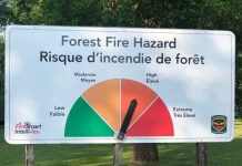
- The wildland fire hazard is high to extreme in the southeastern portion of the region and low to moderate in the western portion of the region along the Manitoba border. There is rain in the forecast.
- To see the fire hazard near you, consult the interactive fire map at Ontario.ca/forestfire
Fires of Note
Nipigon 7 – Located 45 kilometers northeast of the town of Nipigon. This fire is not under control at 600 hectares. Crews have set-up sprinklers on structures in the vicinity of the fire.
Nipigon 8 – Located 40 kilometers northeast of the town of Nipigon. This fire is not under control at 150 hectares. Sections of this fire received air attack today and crews are being sent to the fire.
Thunder Bay 33 – Located 141 kilometres north of Thunder Bay in the Holinshead Lake area. This fire is not under control at 300 hectares. The public is urged to stay out of this area. Crews and aircraft will be working in the vicinity of the fire. Crews and heavy equipment are making great progress on this fire and are establishing line on the south, west and east sides of the fire.
Thunder Bay 36 – Located near Bedivere Lake, approximately 30 kilometres southwest of Upsala. This fire is not under control at 186 hectares and is receiving air attack.
Follow Ontario’s Outdoor Burning Regulations
Aviation, Forest Fire and Emergency Services would like to remind the public to use caution when performing any outdoor burning. In order to dispose of yard waste and woody debris, we encourage you to use methods such as composting or using your local landfill. If you must burn, follow Ontario’s outdoor burning regulations.
Fires are to be ignited no sooner than 2 hours before sunset and extinguished no later than 2 hours after sunrise.
Always have tools/water adequate to contain the fire at the site.
Know the rules for safe outdoor burning.

