Thunder Bay – Wildfire Update – There were 15 new wildfires confirmed on Monday, June 7, 2021. There are a total of 54 active fires in the region.
Northwest Region
- There were 15 new fires confirmed in the northwest region by the late afternoon of June 7.
- Thunder Bay 31 is not under control at 1 hectare and is located approximately 8 kilometres northwest of Raith.
- Thunder Bay 32 is not under control at 0.1 hectares and is located near Whitefish Lake, approximately 46 kilometres southwest of Thunder Bay.
- Fort Frances 25 is not under control at 0.1 hectares and is located near Messada Lake, approximately 22 kilometres northeast of Atikokan.
- Fort Frances 26 is not under control at 0.1 hectares and is located near Mink Lake, approximately 40 kilometres east of Atikokan.
- Nipigon 7 is not under control at 30 hectares and is located near Jake Lake, approximately 46 kilometres northeast of Nipigon
- Thunder Bay 33 is not under control at 10 hectares and is located near Holinshead Lake, approximately 141 kilometres north of Thunder Bay
- Nipigon 8 is not under control at 20 hectares and is located near Foam Lake, approximately 41 kilometres northeast of Nipigon.
- Kenora 41 is being held at 0.2 hectares and is located near Snowshoe Lake, approximately 100 kilometres northwest of Kenora.
- Thunder Bay 34 is not under control at 0.1 hectares and is located near Little Hicky Lake, approximately 60 kilometres northeast of Thunder Bay
- Fort Frances 27 is not under control at 5 hectares and is located near Entwine Lake, approximately 77 kilometres northeast of Fort Frances.
- Thunder Bay 35 is not under control at 0.1 hectares and is located near Smoothrock Lake, approximately 33 kilometres northwest of Armstrong.
- Dryden 37 is not under control at 0.5 hectares and is located near Nora Lake, approximately 24 kilometres southwest of Ignace.
- Thunder Bay 36 is not under control at 30 hectares and is located near Bedivere Lake, approximately 30 kilometres southwest of Upsala
- Kenora 42 is not under control at 0.2 hectares and is located near Highwind Lake, approximately 43 kilometres southeast of Kenora.
- Kenora 43 is not under control at 0.1 hectares and is located near Colonna Lake, approximately 59 kilometres northeast of Kenora.
- There were two more fires after yesterday’s report for a total of ten fires on Sunday June 6.
- At the time of this update there were 54 active fires in the region. 24 fires are not under control, four are being observed, 10 fires are being held and 16 fires are under control.
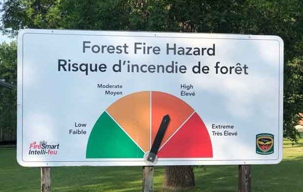
- The wildland fire hazard is high to extreme in the southern half of the region along the Minnesota border. The northern half of the region has a low to moderate hazard.
- To see the fire hazard near you, consult the interactive fire map at Ontario.ca/forestfire
Follow Ontario’s Outdoor Burning Regulations
Aviation, Forest Fire and Emergency Services would like to remind the public to use caution when performing any outdoor burning. In order to dispose of yard waste and woody debris, we encourage you to use methods such as composting or using your local landfill. If you must burn, follow Ontario’s outdoor burning regulations.
Fires are to be ignited no sooner than 2 hours before sunset and extinguished no later than 2 hours after sunrise.
Always have tools/water adequate to contain the fire at the site.
Know the rules for safe outdoor burning. To consult the full set of outdoor burning regulations under Ontario’s Forest Fire Prevention Act, visit our website at ontario.ca/page/outdoor-fire-rules-and-permits.


