

Thunder Bay – WEATHER – Cold weather has its grip on the region this morning. It is -27°C in Thunder Bay, the cold spot in Ontario is -35.2 °C in Fort Frances, and there are Extreme Cold Warnings in effect for all areas of Western Ontario that are west of Thunder Bay.
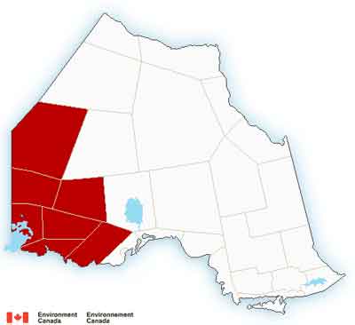
There is also an warning out for Pikangikum, Poplar Hill, MacDowell, Sandy Lake, Weagamow Lake and Deer Lake in Northern Ontario.
Extreme Cold Warnings
- Atikokan – Shebandowan – Quetico Park
- Fort Frances – Emo – Rainy River
- Seine River Village – Mine Centre
- Dryden – Vermilion Bay
- Ignace – English River
- Savant Lake – Sturgeon Lake
- Sioux Lookout – Eastern Lac Seul
- Kenora – Grassy Narrows – Whitedog
- Sioux Narrows – Nestor Falls – Morson
- Ear Falls – Perrault Falls – Western Lac Seul
- Red Lake – Woodland Caribou Park
- Pikangikum – Poplar Hill – MacDowell
- Sandy Lake – Weagamow Lake – Deer Lake
Extreme wind chill values near minus 40°C are expected early this morning and again tonight into Thursday morning.
The cause is a cold arctic airmass which will continue to give frigid temperatures to portions of the region. Temperatures in the minus thirties along with winds of 5 to 10 km/h will result in wind chill values near minus 40°C this morning.
Similar temperatures and wind chills are expected tonight into Thursday morning.
Thunder Bay Weather Outlook
At 06:00 am EST in Thunder Bay it is -27°C on the way to a daytime high of -17°C. There will be a mix of sun and cloud today with a 30 percent chance of flurries early this morning. Winds will become northwest 20 km/h near noon. Thunder Bay is only two degrees from being in the Extreme Cold Warning zone this morning. The wind chill is at 38°C this morning and -27°C this afternoon. There is a risk of frostbite for exposed skin. There is also a danger to cats, dogs and livestock at these temperatures.
Tonight, the forecast is calling for a few clouds. Winds will be northwest 20 km/h becoming light early this evening. The overnight low will be -29°C. Wind chill will make that feel more like -27°C this evening and -37°C overnight.

Greenstone Geraldton Weather
It is -20°C this morning in Geraldton under mainly cloudy skies. There is a 30 percent chance of snow flurries. Winds will be up to 15 km/h. It won’t be warming up all that much today, the daytime high will be -17°C. The wind chill will make that feel like -29°C. There is a risk of frostbite.
Tonight, the skies will be partly cloudy. Winds will be up to 15 km/h. The overnight low will be -28°C, with the wind chill at -27 this evening and -38°C overnight. There is a risk of frostbite.
Pikangikum Weather Outlook
The Extreme Cold Warning is in effect for Pikangikum this morning. It is -34°C with a forecast high of -22°C for the day. Skies are expected to be clear today, with winds up to 15 km/h. Wind chill values are at -45°C this morning and -27°C this afternoon. Frostbite to exposed skin at these temperatures can happen in mere minutes.
Tonight the overnight low will be -36 with the wind chill at -28°C this evening and -42°C overnight.
Fort Frances Weather
As of 06:00 Fort Frances is the cold spot in Ontario at -35°C, headed to a daytime high of -19°C. Winds up to 15 km/h, meaning the wind chill is -41°C this morning and will be -23°C this afternoon. There is a risk of frostbite for exposed skin. There is also a danger to cats, dogs and livestock at these temperatures.
Tonight expect a few clouds. Wind up to 15 km/h. The overnight low is forecast for -31°C. The wind chill will be -25°C this evening and then fall to a chilly -40°C overnight.


