
by Edgar J. Lavoie
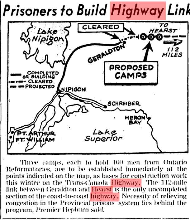
GERALDTON – LIVING – This article from The Globe and Mail, October 24, 1939, is remarkable for several reasons.
Some reporter at his desk in Toronto put together this sketch and the facts at his command. He was struggling with those facts.
There was indeed a highway from Port Arthur to Geraldton. The road to Nipigon was indeed completed. The stretch that is “completed or building” suggests that the road to Geraldton is passable. However, in late 1939, the road from Nipigon to Geraldton was still under construction. Not until September 7, 1940, was the highway from Nipigon (still called Highway 11) declared officially open.
Another thing: The distance from Geraldton to Hearst was 153 miles, not 112. And the right of way was not yet cleared. The prisoners would begin the clearing.
Here arises a confusion. There was a right of way cleared from Geraldton to Longlac (community not shown). It began on the north edge of Geraldton and ran in an arc towards Longlac. However, this right of way was abandoned in 1940 in favour of the current right of way, which begins on the south edge of Geraldton, and crosses Kenogamisis Lake on two bridges before continuing to Longlac.
The “projected” highway appears to start at Longlac (not shown) and run towards Hearst (not shown). True, as far as it goes. Strictly speaking, the term “projected” should apply to the distance between Geraldton and Hearst. On the map, the figure of “112 miles” appears to apply to the projected highway between Longlac and Hearst. In fact, the mileage is closer to 128 miles.
The proposed camps “from Ontario Reformatories” did indeed number three. They were just east of Longlac (not shown) and definitely not close to Hearst, as the map implies. On November 2, the Globe named “the Burwash Farm” as the source of convict labour (more precisely, it should read “the Burwash Industrial Farm”, located near Sudbury).
The highway along the North Shore (Highway 17) did indeed extend from Nipigon to Schreiber. I get a thrill every time I read stuff like “bases for construction work this winter on the Trans-Canada Highway”. The road from Nipigon to Hearst was indeed designated as the Trans-Canada Highway, but so was the road from Nipigon to Schreiber. You can see how people might become confused.
In fact, the official stance of our provincial and federal governments today is that the North Shore route was the first Trans-Canada Highway. This is simply not true. The Last Link Project volunteers (sponsored by Greenstone Historical Society) have already educated several provincial and federal cabinet ministers in this respect, and enlisted their support. The truth is the link between Geraldton and Hearst completed the first Trans-Canada Highway. Traffic was allowed to flow in June 1943. The link between Schreiber and the Soo was not completed until 1960. The primary purpose of The Last Link Project is set the historical record straight.
Dating from June 1943, for the first time, motor traffic could travel on a continuous road between the Atlantic and Pacific Oceans on a completely Canadian transcontinental highway.
This historical article demonstrates the folly of trusting everything a newspaper prints. However, there is no doubt that this article stimulated the imagination of readers and conveyed the essential story that the final link in the Trans-Canada Highway was being constructed between Geraldton and Hearst back in 1939.
Edgar Lavoie
[The author is a writer and historian based in Greenstone, north of Lake Superior.]


