
THUNDER BAY – WEATHER – NASA satellites provided forecasters with infrared and visible imagery of Major Hurrricane Lester as it continued to move through the Eastern Pacific Ocean. After peaking as a Category 4 hurricane on Aug. 29, Lester weakened to a Category 3 hurricane on the Saffir-Simpson Hurricane Wind Scale today, Aug. 30.
On Aug. 29 at 7:25 p.m. EDT (23:25 UTC) NASA-NOAA’s Suomi NPP satellite passed over Lester and the Visible Infrared Imaging Radiometer Suite (VIIRS) instrument aboard NASA-NOAA’s Suomi NPP satellite captured a visible image of the storm when it was a Category 3 hurricane. The VIIRS image showed a cloud-free eye about 20 nautical miles wide, surrounded by powerful thunderstorms.
At 11 p.m. EDT, the National Hurricane Center noted Lester reached its peak with maximum sustained winds near 140 mph (220 kph), making it a Category 4 Hurricane. Lester was symmetrical.
By Aug. 30, however, the National Hurricane Center (NHC) noted that Lester was showing signs of weakening as maximum sustained winds decreased. NHC forecaster Kimberlain said that “The areal extent of deep convection within the hurricane’s central dense overcast (CDO) has decreased substantially, and the CDO has lost much of its axisymmetry since late yesterday [and does not appear as rounded].”
At 5 a.m. EDT (2 a.m. PDT/0900 UTC) on Aug. 30 there were no coastal watches or warnings in effect. The center of Hurricane Lester was located near18.2 degrees north latitude and 133.2 degrees west longitude. That puts Lester’s eye about 1,435 miles (2,305 km) east of Hilo, Hawaii, and east of Category 4 Hurricane Madeline.
The NHC said that Lester is moving toward the west near 14 mph (22 kph), and this general motion is expected to continue for the next couple of days. The estimated minimum central pressure is 956 millibars.
Maximum sustained winds have decreased to near 125 mph (205 kph) with higher gusts. Lester is a category 3 hurricane on the Saffir-Simpson Hurricane Wind Scale. Some weakening is forecast during the next 48 hours.
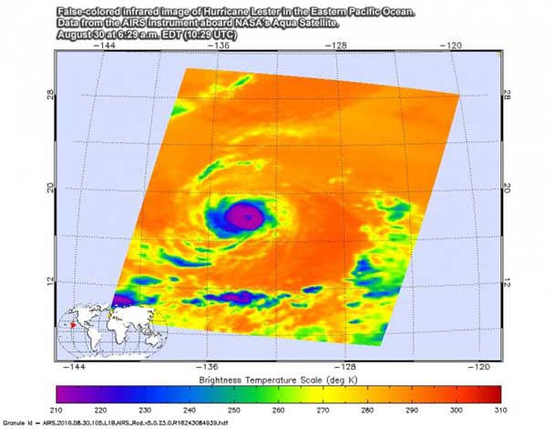
At NASA’s Jet Propulsion Laboratory in Pasadena, California, infrared data from the Atmospheric Infrared Sounder or AIRS instrument that flies aboard NASA’s Aqua satellite was made into a false-colored infrared image from data taken on Aug. 30 at 6:29 a.m. EDT (10:29 UTC). Infrared data provide temperatures, and the AIRS image showed powerful storms with very cold cloud top temperatures in excess of minus 63 degrees Fahrenheit (minus 53 degrees Celsius) surrounding what appeared to be a less-defined eye.
NHC forecasts call for Lester to continue in a westerly direction before turning to the west-northwest on Aug. 30. For updated forecasts, visit the NHC website at: http://www.


