THUNDER BAY – There were no new fires confirmed by the afternoon of May 27 in the Northwest Region. There are rain showers in the forecast for parts of the region over the next twenty-four hours.
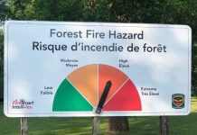
The fire hazard is low to moderate in the western portions of the region and moderate to high in the eastern portions of the region.
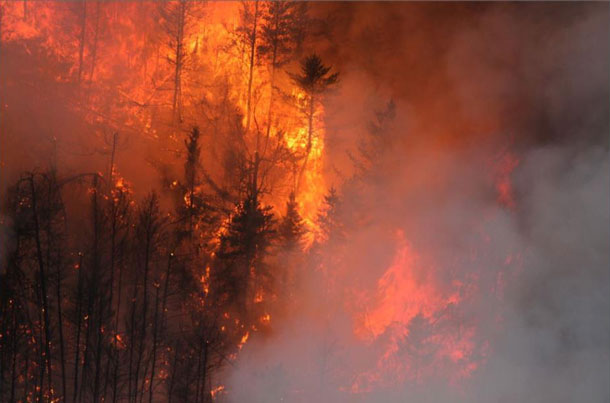
Nipigon District Fire Number 15 is a lightning-caused fire that started on May 23rd and is not under control at 145 hectares in size. It is located 11 kilometers east of Neskantaga First Nation and crews are still being deployed to this fire today.
Nipigon District Fire Number 14 west of Geraldton is under control at 12 hectares in size. It is now smouldering in a patchy burn that FireRanger crews are working to put out.
Nipigon District Fire Number 13, located north of Geraldton, adjacent to the airport has been remapped at 286 hectares in size with a status of not under control. Fire behaviour was minimal today and crews are continuing to establish hose lines around the fire.
Kenora Fire Number 18 is in good shape and listed as being held.
Red Lake District Fire Number 3 which is listed as not under control at approximately 86,027 hectares and is straddling the border between Ontario and Manitoba. This fire size includes both Manitoba and Ontario portions of the fire. There is minimal fire behaviour on this fire and crews are working to consolidate lines along the southern and northern excursions. More crews are being placed on this fire today.
An emergency area order is now in place on a section of the fire. For public safety and effective fire suppression, until further notice, all travel and use of the Iriam Loop Road from Black Bear Lodge on the North end to the intersection of the South Pakwash Road on the south end, including all Branch Roads off the Iriam Loop Road is prohibited unless authorized by a travel permit issued by the Red Lake District of the Ministry of Natural Resources and Forestry.
Thunder Bay District Fire 019 is located about 40 kilometers north of Raith in the Dog River Road area and has been remapped to a more accurate size of 868 hectares. The fire is exhibiting minimal fire behaviour today. The fire is 75% contained and crews continue to consolidate hose lines around the fire.
An emergency area order is now in place over the fire and travel restrictions are in place including all travel and use of the Dog River Road northward from the junction of the Dog River Road and Sideen Road; the Dog River Road southward from the junction of the Dog River Road and the Chismore Road, and the Pakashkan Road southward from the junction of the Pakashkan Road and the Chismore Road. Also, all use and occupation of Crown Land on or within 500 meters of the described closed roads noted above within this area is prohibited.
The Restricted Fire Zone remains in effect across the Northwest Region as shown on this map
Enforcement patrols are being conducted in the region to ensure people are not in violation of the restriction on outdoor fires currently in place across the Northwest Region except for the far north. Charges and fines have been laid as a result of these patrols, and public reports continue to come in of people setting campfires and large bon fires.
Out of Province
Following a resource request made by Ontario to the Canadian Interagency Forest Fire Centre (CIFFC), Ontario has received 121 fire response personnel from Saskatchewan, British Columbia and Newfoundland as of May 26.
Ontario has also received 20 personnel from Wisconsin as part of the Great Lakes Forest Fire Compact (GLFFC). GLFFC is made up of three U.S. States and two Canadian Provincial Natural Resources agencies. They have created a formal association in order to promote effective prevention, pre-suppression and control of forest fires in the Great Lakes Region of the United States and adjacent areas of Canada.
Ontario has sent two flight coordinators to CIFFC in Winnipeg, Manitoba to assist in coordinating national aircraft for interprovincial / international movements of firefighting staff.
Ontario currently has 85 personnel deployed in Alberta, including FireRangers, Agency Representatives, Division Supervisors, Strike Team Leaders, Helicopter Officers, a Supply Unit Leader a Service Branch Director and an Incident Management Team.
Use of Unmanned Aerial Vehicles around Forest Fires
In Canada, the official designation for unmanned aircraft is Unmanned Aerial Vehicles (UAV’s) however Remotely Piloted Aircraft (RPA), drones, etc. were used in the past, now collectively these designations are classified as UAV’s. The actual flying aircraft may still be called UAV, ROA, RPA, drone, etc. by the general public, operators and users.
With more and more people flying UAV’s commercially or simply for the fun of flying, the exposure to possible airspace incursions involving an UAV have increased.
We would like to remind the public that flying UAV’s around forest fires is both dangerous and illegal. When you fly a UAV or drone near a forest fire you can put the lives of pilots, firefighters and other emergency workers at risk. The delays and distractions associated with having one of these aircraft in the area could also put the lives of the public and the safety of their homes at risk when a forest fire is being actioned. Always think safety first and keep your UAV or drone away from forest fires.
Restricted Air Fly Zone
The following are the airspace restrictions for all aircraft over forest fires.
Forest Fire Aircraft Operating Restrictions
601.15 No person shall operate an aircraft
- (a)over a forest fire area, or over any area that is located within five nautical miles of a forest fire area, at an altitude of less than 3,000 feet AGL; or
- (b)in any airspace that is described in a NOTAM issued pursuant to section 601.16.
Transport Canada is responsible regulating the use of UAV’s and keeping the public and our airspace safe. If an incident is reported to the department, one of Transport Canada’s inspectors will verify that the operator followed the rules and whether the UAV safety guidelines were followed and fines could be as much as 25,000 dollars or imprisonment. Local police may also be involved if other laws were broken, including the Criminal Code and privacy laws.
Safe operation of UAVs information can be found on Transport Canada’s Website.
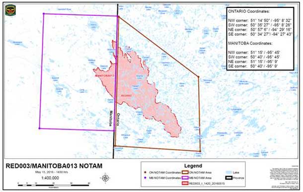
Aircraft flight restrictions over Red Lake fire
There is a Notice to Airmen (NOTAM) advisory in place for Red Lake District Fire Number 003 regarding flight operations over the fires, including the Woodland Caribou Provincial Park area west of Red Lake.
Pilots can access the information for the Red Lake advisories here . Aircraft requiring authorization to enter or depart the NOTAM area can contact the following: Red Lake Fire Management Headquarters – 807-727-2055 Firefighting aircraft are using and monitoring VHF-AM Frequency 122.40 within both restricted flight areas.
For more information about the current fire situation, the active fires map and the restricted fire zones go to ontario.ca/forestfire
To view the Restricted Fire Zone Map online go to this page and select Restricted Fire Zones as a layer.
The Northwest Region Fire Information Hotline is available for general information updates – 1-888-258-8842
Woodland Caribou Provincial Park – 807-727-1329
Report forest fires by calling 310-FIRE (3473).

