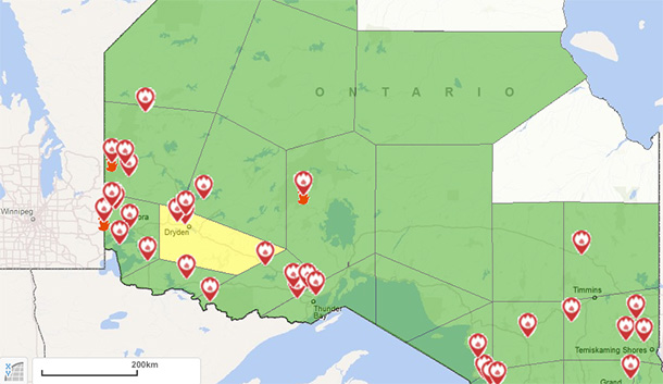
KENORA – WILDFIRE – There were no new fires confirmed in the Northwest Region by the afternoon of May 13. However there are a number of wildfires burning across the region. The precipitation in the region has not led to the restricted fire zone being rescinded.
One fire of note is Kenora 018, in the Ingolf area about 55 kilometers west of Kenora. It was last estimated at 5,800 hectares in size during the morning of May 11, and is not under control. Hydro lines were not damaged, but an unoccupied trapper’s cabin on North Cross Lake on the Manitoba side of the fire was lost.
Progress on Fires in Kenora Region
Fire crews and heavy equipment are making good progress on all sides of the fire. The fire is approximately 50% contained. The entire east side of the fire has been tied in, and heavy equipment lines continue to be established along the west flank. Infrared scanning will be taking place starting at the south end of the fire along Longpine and Macara Lakes and then progressing to other areas where lines have been consolidated. With the present weather conditions, we do not expect the fire to spread again today, or become active in the interior for the next several days.
Residents of Tannis Lake will be permitted to return to their properties on Saturday, May 14 at 9:00 a.m. Only the evacuation at Tannis Lake is being lifted at this time – residents must bring identification and proof of property ownership and will be issued a travel permit. Travel permits will only be issued on the Gundy Lake Road when residents return.
Another fire of note is Red Lake Fire 003 which is listed as not under control and is straddling the border between Ontario and Manitoba. The fire has been remapped at 75 000 hectares and is approximately 30 per cent contained. Cold weather with intermittent snow and rain has led to little spread on Red003. This has enabled Fire crews to make some progress. However, that same weather has hampered flying conditions and is making it a challenge to get all crews in position for fire suppression.
Canvas tents and heaters have been brought in to ensure adequate hospitality for crews and staff in the field. Further, an Incident Command trailer now up and operational.
The Ontario portion of the fire is located in Woodland Caribou Provincial Park and Ontario Parks strongly cautions people to avoid the southwest portion of the park while suppression action is under way. Assessment for closures of routes or portage continue so people are advised to check with the park office for updates and information on possible route or access closures. The contact number is 807-727-1329.
Restricted Fire Zone
The Ministry of Natural Resources and Forestry has declared a Restricted Fire Zone in much of Northwestern Ontario to reduce the risk of human-caused wildfires.
Effective May 07 at 0001 daylight time, the Restricted Fire Zone was put in place and will remain in effect until conditions improve.
Under the Restricted Fire Zone all open fires are prohibited. Campfires may be allowed at some organized campgrounds or parks that use approved fire pits and meet certain other criteria. Campers should check with the owners or operators first. Within the Restricted Fire Zone area, people can still use portable gas stoves for cooking and warmth but the public is asked to exercise extreme caution. Fire staff and conservation officers will strictly enforce the restrictions on open burning.
Emergency Area Order – restricted travel on designated roads
An Emergency Area Order has been declared in the Kenora District over Kenora Fire 018. The fire has road restrictions under this Emergency Area Order. All travel and use of the Gundy Lake Road from the Junction north of Hwy 17 is prohibited; White Road is closed at the intersection of the White Road and the Malachi Lake Road; the Ingolf Road at the Ontario Manitoba border. Travel is prohibited unless authorized by a travel permit issued by the Kenora District of the Ministry of Natural Resources and Forestry. All use and occupation of Crown Land on or within 500 meters of the described closed roads above is prohibited. This Order came into effect at 4:35 PM Central Daylight Time on May 6, 2016 and will remain in effect until such time as the order is revoked.
Evacuation Return Protocol
To facilitate a safe and orderly return of evacuated property owners to their properties, the Ontario Provincial Police (OPP), Ontario Ministry of Natural Resources and Forestry (MNRF) and the Manitoba Department of Sustainable Development have developed a protocol to ensure evacuees have access to their properties and can do so in a safe and secure manner.
- All property owners will be allowed to return at the appointed date and time, once the fire officials have determined that it is safe to do so.
- This will be a permanent return to the properties.
- To maintain the security of properties and to ensure that only property owners/evacuees are allowed into the evacuation area once the return is authorized, we ask that returnees limit themselves to one vehicle on the date of the return.
- Limiting property owners to one vehicle on the day of the return will speed up the return process and manage public safety risks.
- We ask that property owners bring with them, proof/evidence of their connection to the property, such as:
- a recent tax bill, OR
- information on property PIN number or lot number, OR
- a piece of mail directed to the property, AND
- personal identification.
- If the person is a designee of the property owner, they must also have documentation from the property owner that they have permission to enter the property.
- A travel permit will be issued to the property owner (or designee) to permit travel on the closed road.
- Emergency response personnel will maintain the barricades at the closed roads to the evacuated areas.
Out of Province
Ontario deployed 82 personnel on the afternoon of May 6 to support firefighting efforts in Alberta.
For more information about the current fire situation, the active fires map and the restricted fire zones go to ontario.ca/forestfire
To view the Restricted Fire Zone Map online go to this page and select Restricted Fire Zones as a layer.
To view a map of the Emergency Area Order and restricted roads – go to this page.
The Northwest Region Fire Information Hotline is available for general information updates – 1-888-258-8842
Kenora Fire 018 Public Information – 807-548-1919
Woodland Caribou Provincial Park – 807-727-1329
Report forest fires by calling 310-FIRE (3473).
Follow Aviation Forest Fire Emergency Services on its new Twitter account


