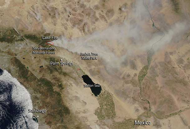

CREDIT – Courtesy Jeff Schmaltz LANCE/EOSDIS MODIS Rapid Response Team, GSFC
Dry Weather in California Impacts Wild Fire Conditions
SAN BERNARDINO – WILD FIRE – Wild Fire dangers in California are being impacted by hot dry weather.
Also of serious concern is the Big Bear Fire.
The lake fire located i n San Bernardino National Forest was reported just before 4:00 p.m. on June 17.
The cause of the fire is still under investigation.
This wild fire is approximately 11,000 acres in size and burning in timber. It is currently 10 percent contained. There are approximately 150 structures threatened, however no structures are believed to be damaged or destroyed at this time.
Big Bear High School faculty and students had to relocate their graduation ceremony due to the fire’s proximity.
Weather Conditions Hit Hard
Making matters more difficult a high-pressure weather system is in place with above normal temperatures over the next several days and very low daytime humidity (5 to 10 percent). That weather report is conducive to a continuation of the fire’s activity. All hiking trails into the San Gorgonio wilderness area have been closed due to the proximity of the fire to many hiking trails. The Pacific Crest Trail (PCT) is closed from Whitewater Preserve to Onyx Summit according to Inciweb.
June 18 and overnight into June 19, the fire pushed further east into the Heart Bar area and Coon Creek area, and also moved farther South into the San Gorgonio wilderness area in the Ten Thousand Foot Ridge area. Due to turbulent winds above and near ridge lines, helicopters have been more effective than air tankers in slowing the fire. Additional resources have been ordered and will be arriving over the coming days.
NASA’s Aqua satellite collected this natural-color image with the Moderate Resolution Imaging Spectroradiometer, MODIS, instrument on June 18. Actively burning areas, detected by MODIS’s thermal bands, are outlined in red.
