Thirty-Five Deaths from Storms in US
PASADENA – Weather – Tornadoes, and heavy rain with up to ten inches of water fell overnight in parts of the United States. Over the course of this storm, thirty-five people have died. The tornadoes, thunder storms and flooding are impacting a wide area of the United States.
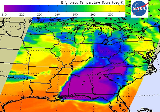
NASA reports that “The weather system that dropped tornadoes in seven central and southern U.S. states on April 27-28, moved east and generated more tornadoes on April 29. NASA’s Aqua satellite gathered temperature data on the thunderstorm cloud tops in the system and found them to be higher in the atmosphere and colder. The tornado outbreak over the evening and overnight hours of April 28-29 is thought to have generated more tornadoes in northern Mississippi and Alabama”.

Image Credit:
NASA/JPL, Ed Olsen
NASA’s Aqua satellite passed over the eastern U.S. early in the morning on April 29 at 07:41 UTC/3:41 a.m. EDT and gathered infrared data associated with the storms associated with the frontal system that generated tornadoes on April 28 and early this morning, April 29. The Atmospheric Infrared Sounder (AIRS) instrument that flies aboard NASA’s Aqua satellite provided that infrared data. A false-colored image of the storm system using the infrared data was created by NASA’s Jet Propulsion Laboratory (JPL) in Pasadena, Calif.
The AIRS image showed very cold cloud top temperatures indicating that the thunderstorms had strong uplift that pushed cloud tops near the top of the troposphere. Temperatures drop to just under 220 degrees kelvin at the top of the troposphere (and where the tropopause begins).
In the early morning imagery from today (April 29) AIRS data showed minimum temperature to be near 190 kelvin (-117.7 F/-83.1 C), which is even colder than yesterday. That means the storms early this morning were higher in the atmosphere and had the potential to be stronger than those on April 28. On April 28, AIRS data showed some thunderstorms with cloud tops as cold as 200 kelvin (-99.6 F/-73.1C).
A low pressure center associated with the fronts is located over Iowa. A warm front extends east of the low bringing warm, moist air into the southeastern U.S. A stationary front stretches south from that low pressure area to another low pressure area over eastern Texas. NOAA‘s National Weather Service Storm


