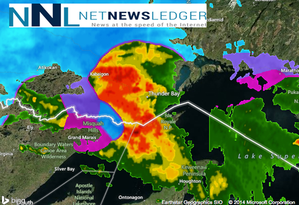
THUNDER BAY – UPDATED – The weather is likely to top Northwestern Ontario’s news today. For Thunder Bay the freezing rain warning remains in effect as of 05:35EDT. Environment Canada reports: “A major winter storm centred over Western Lake Superior will track towards Northeastern Ontario today. Periods of snow mixed with freezing rain and ice pellets continues in a swath extending from the northwest shores of Lake Superior to areas south of James Bay. Close to Lake Superior, a mix of rain and freezing rain is expected until midday when a change to all snow is forecast. For areas further inland, a mixture of snow, ice pellets and freezing rain is more likely with several cm of snow possible.
“Travelers should consider changing their plans as driving conditions will be hazardous with rain and freezing rain causing slippery conditions on untreated surfaces”.
Highway 17 between the Manitoba boundary and Ignace is now open after being closed overnight – Police are suggesting staying off the highways. Other highways across Northwestern Ontario are closed.
Thunder Bay Road Crews are out, sidewalks in many areas are being cleared but walking will be somewhat difficult in some place.
For Thunder Bay: ALL RURAL BUS ROUTES CANCELLED
The following Lakehead Public Schools are Closed
- Crestview
- Five Mile
- Gorham Ware
- Kakabeka Falls
- McKenzie
- Nor’wester View
- Whitefish Valley
- Valley Central
- As well as the Lakeshore Area of Claude Garton and the Rosslyn Road area of Westmount
- Including all Lakehead Public School Secondary Students from these areas ***
The following rural portions of urban routes are cancelled
Westmount
- South #22 – Rural Portion of the Route
- South #23 – Rural Portion of the Route
- South #24 – All of the Route
Claude Garton
- North #22 – All of the Route (P.M. stops South of Hwy 11/17 will be taken by North #19
- Eagle – All of the 7 & 8’s from the McKenzie area
- St. Paul – Lakeshore Yellow Bus
Agnew (French Immersion
- South #10 – All of the Route
- South #25 – All of the Route (not Spec. Ed.)
- South # 22 – P.M. only
Woodcrest
- North #13 – All of the stops North of Wardrope
Ecole Gron Morgan
- North #2 – Rural Portion
- North #3 – Rural Portion
- North #4 – Rural Portion
- North #6 – Rural Portion
- North #11 – Rural Portion
- North #13 – Rural Portion
Thunder Bay Catholic District School Board Routes
(Includes transportation for Ecole Franco Superieur and Ecole secondaire de La Verendrye)
****** North Ward Schools ******
Corpus Christi
- North 45 – Corpus Christi – Rural – Green
Holy Cross
- North 46 – Holy Cross – Government Rd – Blue
- North 47 – Holy Cross – John St. Rd. – Green
- North 72 – Rural Portion of Holy Cross – Oliver Rd. – Yellow
Our Lady of Charity
- North 74 – Our Lady of Charity – Rural – Orange
- North 46 – Holy Cross – Government Rd – Blue
- North 47 – Holy Cross – John St. Rd – Green
- North 42 – Bishop Gallagher – Hilldale
St. Bernard
- North 53- St. Bernard – Oliver Rd – Gold
- North 55 – Rural Portion of St. Bernard – Jumbo Gardens – Lime
- North 48 – Rural Portion of St. Bernard – County Park – Green
- North 52 – Rural Portion of St. Bernard – Dawson/Grandview – Turquoise
- North 78 – Franco Superieur – North Rural – Orange
- North 76 – St. Paul – Copenhagen – Green
- North 77 – Bishop Gallagher/St. Ignatius/St. Bernard/Franco Superieur – Lakeshore Dr. Route
St. Margaret
- North 75 – St. Paul/St. Margaret – Gorham Blue – Onion Lake Rd – Yellow
- North 53 – St. Bernard – Oliver Rd – Gold
St. Paul
- North 76 – St. Paul – Copenhagen – Green
- North 75 – St. Paul – Gorham – Blue
- North 77 – St. Paul – Lakeshore Drive routes
Ecole catholique Franco Superieur
- North 78 – Franco Superieur – North Rural – Orange
- North 79 – Rural Portion of Franco Superieur – Southward – Red
- North 53 – St. Bernard – Oliver Rd – Gold
- North 47 – Holy Cross – John Street Rd Green
- North 55 – Rural Portion of St. Bernard – Jumbo Gardens – Lime
- North 52 – Rural Portion of St. Bernard – Dawson/Grandview – Turquoise
- North 48 – Rural Portion of St. Bernard – County Park – Green
- North 44 – Bishop Gallagher/St. Ignatius/St. Bernard/Franco Superieur – Lakeshore Dr. Route
- North 76 – St. Paul – Copenhagen – Green
- North 75 – St. Paul – Gorham – Blue
- South 55 – Rural Portion of St. Martin – North Rural – Blue
- South 61 – Rural Portion of St. Martin – South Rural – White
- South 43 – St. Ann – Hwy 608
- South 45 – St. Ann – Mountain Road
Bishop E.Q. Jennings
- North 35 – E.Q. Jennings – Dawson Rd
- North 34 – E.Q. Jennings – Oliver Rd
- North 32 – Rural Portion of E.Q. Jennings – Jumbo North
- North 33 – Rural Portion of E.Q. Jennings – Jumbo South
Bishop Gallagher
- North 42 – Bishop Gallagher – Dawson/Hilldale
- North 38 – Rural Portion of Bishop Gallagher – Court/Central
- North 40 – Rural Portion of Bishop Gallagher – County Park – East
- North 41 – Rural Portion of Bishop Gallagher – County Park – West
- North 36 – Rural Portion of Bishop Gallagher – Current River
- North 43 – Bishop Gallagher/St. Ignatius – Kam Van
- North 76 – St. Paul – Copenhagen – Green
- North 75 – St. Paul – Gorham – Blue
- North 44 – Bishop Gallagher/St. Ignatius/St. Bernard/Franco Superieur – Lakeshore Dr. Route
- North 74 – Our Lady of Charity – Rural – Orange
St. Ignatius / Ecole secondaire catholique de La Verendrye
- North 65 – St. Ignatius – Dawson Rd
- North 58 – St. Ignatius – Hilldale Rd
- North 67 – St. Ignatius – Oliver Rd
- North 66 – Rural Portion of St. Ignatius – Southward
- North 56 – Rural Portion of St. Ignatius – County Park East
- North 57 – Rural Portion of St. Ignatius – County Park West
- North 59 – Rural Portion of St. Ignatius – Jumbo North
- North 60 – Rural Portion of St. Ignatius – Jumbo South
- North 68 – Rural Portion of St. Ignatius – Shuniah
- North 47 – Holy Cross – John St. Road – Green
- North 76 – St. Paul – Copenhagen – Green
- North 75 – St. Paul – Gorham – Blue
- North 42 – Bishop Gallagher – Hilldale
- North 43 – Bishop Gallagher/St. Ignatius – Kam Van
- North 44 – Bishop Gallagher/St. Ignatius/St. Bernard/Franco Superieur – Lakeshore Dr. Route
- North 74 – Our Lady of Charity – Rural Orange
- North 78 – Franco Superieur – North Rural – Orange
***** South Ward Schools *****
Holy Family
- All Routes servicing the school
St. Ann
- South 76 – St. Ann – Mountain Rd
- South 44 – St. Ann – Hwy 61 East
- South 45 – St. Ann – Riverdale/Mt. Forest
- South 75 – St. Ann – Cloud Lake
- South 43 – St. Ann – Hwy 608
- Fort William First Nation Bus
St. Martin
- South 55 – Rural Portion of St. Martin – North Rural Blue
- South 61 – Rural Portion of St. Martin – South Rural White
- South 76 – St. Ann – Mountain Rd
- South 44 – St. Ann – Hwy 61 East
- South 45 – St. Ann – Riverdale/Mt. Forest
- South 75 – St. Ann – Cloud Lake
- South 43 – St. Ann – Hwy 608
- Fort William First Nation Bus
- South 94 – Whitefish Valley – Kangaroo – AM
- South 98 – Whitefish Valley – Rooster – AM
- South 29 – Kakabeka – Hippo – AM
Pope John Paul II
- South 67 – Pope John Paul II – Murillo/Arthur
- South 33 – Pope John Paul II – Valley Heights/Rosslyn Village
- South 34 – Pope John Paul II – Vickers Heights/Rosslyn Rd
- South 76 – St. Ann – Mountain Rd
- South 44 – St. Ann – Hwy 61 East
- South 45 – St. Ann – Riverdale/Mt. Forest
- South 75 – St. Ann – Cloud Lake
- South 43 – St. Ann – Hwy 608
- Fort William First Nation Bus
- South 36 – Holy Family- Conmee
- South 38 – Holy Family – O’Connor
- South 65 – St. Patrick – Murillo/Arthur
- South 56 – St. Patrick – Hwy 61
St. Patrick
- South 65 – St. Patrick – Murillo/Arthur
- South 56 – St. Patrick – Hwy 61
- South 41 – St. Patrick – Broadway
- South 66 – St. Patrick – Rosslyn Rd
- South 67 – Pope John Paul II – Murillo/Arthur
- South 33 – Pope John Paul II – Valley Heights/Rosslyn Village
- South 76 – St. Ann – Mountain Rd
- South 44 – St. Ann – Hwy 61 East
- South 45 – St. Ann – Riverdale/Mt. Forest
- South 75 – St. Ann – Cloud Lake
- South 43 – St. Ann – Hwy 608
- Fort William First Nation Bus
- South 36 – Holy Family- Conmee
- South 38 – Holy Family – O’Connor
- North 43 – Bishop Gallagher – Kam Van
For Dryden / Kenora: All School Buses have been cancelled for the day on Tuesday, April 1 in the following areas:
KENORA/SIOUX NARROWS
DRYDEN/VERMILION BAY
RED LAKE/EAR FALLS
SIOUX LOOKOUT
IGNACE
UPSALA
Closures across the Region:
The Sioux Mountain Children’s Centre is closed for today.
Highway 17 between Ignace and Thunder Bay is reported closed.
Highway 502 from Dryden to Fort Frances is reported closed.
Highway 71 from Kenora to Fort Frances is reported closed.
Highway 11 from Highway 600 to Highway 71 is reported closed.
Thunder Bay Transit is operating.
Wasaya Airlines reports, “We would like to advise all our passengers travelling today of possible delays, misconnects, and cancellations due to ongoing freezing rain and snowfall forecasted for Northwestern Ontario. If you have any questions regarding your travel today, please direct them to your Northern community agent or you can contact our Reservations department at 1-877-492-7292.


