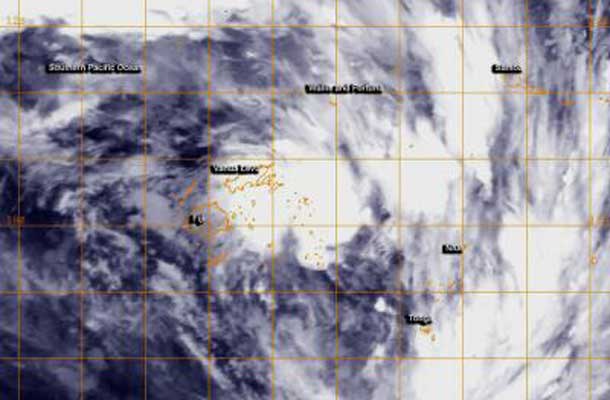
FIJI – Weather – Tropical Cyclone 16P formed near Fiji after lingering in the region for several days as a tropical low pressure area. NOAA’s GOES-West satellite captured an infrared image of the storm on February 28.
NOAA’s GOES-West satellite image showed the center of Tropical Cyclone 16P to the northeast of Fiji and over Vanua Levu. Broken bands of thunderstorms wrapping from the north to the east and southeast reached Wallis and Fortuna, Samoa, Niue and Tonga.
At 0900 UTC/4 a.m. EST, Tropical Cyclone 16P was centered about 170 nautical miles/`95.6 miles/314.8 km northeast of Suva, Fiji near 16.1 south latitude and 179.5 west longitude. 16P had maximum sustained winds near 35 knots/40 mph/62 kph. It was moving to the east-southeast at 9 knots/10.3 mph/16.6 kph, and the Joint Typhoon Warning Center has forecast a more southeasterly track over the next several days.
According to Australia Network News, Tropical Cyclone 16P, as a low pressure area, had already dropped heavy rainfall over the main island of Viti Levu, including the capital Suva. Flooding has been reported in Viti Levu and continued to fall on February 28.
The Fiji Meteorological Service continued their Heavy Rain Warning for southern and eastern Vanua Levu, Taveuni and nearby smaller islands, Lau and Lomaiviti Group. The Fiji Met Service has forecast “periods of heavy rain and squally thunderstorms over southern and eastern Vanua Levu, Taveuni and nearby smaller islands: Lau and Lomaiviti group. Rain expected to ease over eastern and southern Vanua Levu from mid-morning and over Taveuni and nearby smaller islands, Lau and Lomaiviti group from evening.” The warning also warned about the possibilities of flash flooding. For updates, visit: http://www.met.gov.fj.
The Joint Typhoon Warning Center has forecast Tropical Cyclone 16P to move in a southeasterly direction over the next five days.


