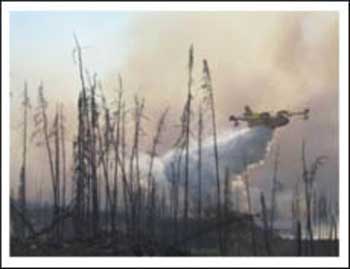
“We are working with the communities in northwestern Ontario to help keep them safe. Protecting people and communities is our priority. A number of communities have evacuated some or all of their people, and we’re there to support and help them in the coordination for the evacuation,” states Linda Jeffrey, the Ontario Minister of Natural Resources. The massive efforts of both fighting the fires in Northwestern Ontario, and of evacuating people from communities across the region are underway.
In the Youtube Video, Dave Cleaveley, the Response and Operations Manager for the Ministry of Natural Resources updates on the situation as it is at present.
Today, the Cabinet Committee on Emergency Management convened and worked to assure that firefighters and personnel on the ground will have the resources needed to evacuate people to safety and extinguish the fires. Over the past several days, over 1500 people have been evacuated from their communities to Thunder Bay, Winnipeg, Kenora, Greenstone, Wawa and other communities. The evacuation of residents of First Nations communities in Northwestern Ontario is continuing due to smoke and immediate threats posed by forest fires.
Emergency Management Ontario (EMO), the Ministry of Natural Resources (MNR), the Canadian Forces and Aboriginal Affairs and Northern Development Canada are working closely together with affected First Nations communities to ensure those in danger are safely evacuated. The government is also working with the communities who are accommodating those who have been evacuated.
The Cabinet Committee on Emergency Management will continue to convene on a daily basis. The Province will continue to collaborate closely with affected community leaders and officials from other levels of government to ensure that all necessary resources are deployed to fight the fires and protect people and ensure their safe evacuation.
EMO is coordinating with local officials in host communities and First Nations leaders to ensure the wellbeing of evacuees and MNR personnel continue to fight multiple fires with ground crews and water bombers and to coordinate the airlift in concert with the Canadian Forces.
“The collaboration of everyone involved is exemplary. It is displayed in the resiliency of First Nations residents, the dedication of the crews fighting fires on the ground and in the air, to the professionalism of those flying vulnerable residents to safety and in the compassion of the volunteers in host communities,” Jim Bradley, Minister of Community Safety and Correctional Services.
Tony Clement, the Minister for FedNor and MP for Parry Sound – Muskoka, will fly to Dryden early tomorrow morning to meet with volunteers, troops and evacuees affected by the wildfires raging in the area. Minister Clement will be joined by the MP for Kenora and Parliamentary Secretary for Aboriginal Affairs, Greg Rickford.
To keep up on the latest Fire Conditions check the Fire Map
Fires to Keep Aware of in the Region:
Red Lake District Fire Number 84 – Jack Welch Incident Management Team
Red Lake 84 – lightning-caused – not under control – 13, 98 hectares in size: This fire is located about 50 kilometres northeast of Ear Falls. The fire has escaped control to the southeast and is again threatening the power line. Efforts are continuing to protect the power line.
Pickle Lake Complex – Rob Moore – BC Incident Management Team
Sioux Lookout Fire 70 – lightning-caused – not under control – This fire is now estimated ad over 70,000 hectares ins size and is in the area of the Musselwhite Mine site.
An Emergency Area Order has been put in place over Sioux Lookout Fire 70 and another fire in the area, Sioux Lookout Fire Number 60. There are restrictions in place on Highway 599 north of Pickle Lake and on a number of waterways in the area of the fires.
Sioux Lookout Fire 35 – lightning-caused – not under control – 79,000 hectares in size: This fire is about nine kilometres east of Mishkeegogamang at its closest point.
An Emergency Area Order remains in effect over the fire and travel restrictions are in place for a section of the Albany River in the vicinity of the fire.
Red Lake District Fire 85 – lightning-caused – being observed – 2926.4 hectares in size:
This fire is located about 100 kilometres northwest of Red Lake and north of Woodland Caribou Park. On July 16, a private cabin was burned by the fire. Lack of rainfall and recent dry, windy conditions resulted in extreme fire behaviour causing the sprinklers that were operating on the site to be ineffective. Fortunately the fire crew was able to evacuate the property owners safely.
[ad#Google Adsense 350×250 sidebaradd]


